For many years, Barbara Reid, a retired Army medical specialist currently living in Puyallup, had one peculiar thing in common with the late British Navy Captain George Vancouver. When she looked at the foothills of Mount Rainier, she couldn’t help but notice a conspicuous, v-shaped geographical feature.
In the spring of 1792, Vancouver was aboard the H.M.S. Discovery in Puget Sound and surveying the natural environment when he noticed the notch. What could lie within and beyond that carved and concave feature? A large river? The Northwest Passage? Vancouver, whose ship was anchored at Restoration Point on the southern end of Bainbridge Island, noted the feature in his journal—“The appearance of a very abrupt division in the snowy range of mountains immediately to the south of Mount Rainier, which was very conspicuous from the ship, and the main arm of the inlet appearing to stretch in that direction from the point we were then upon”—and boarded one of two smaller boats that headed south, past Vashon Island, and into Commencement Bay, only to find what he believed to be a dead end. Vancouver noted: “We were excessively anxious to ascertain the truth, of which we were not long held in suspense. We found the inlet to terminate here in an extensive circular compact bay, whose waters washed the base of mount Rainier.”
Vancouver would go on to name dozens of mountains, waterways, and islands in the Puget Sound area—but the v-shaped notch remained nameless and largely elusive.
That changed several years ago when Reid, 72, started to explore Puget Sound in her own boat. Reid retired from the Army 30 years ago, bought a Swedish-made Albin 25 watercraft in 1999, and soon began to navigate the Columbia River, Snake River, and the route taken by Peter Puget (Vancouver’s lieutenant) as he explored Puget Sound. In total, she logged more than 8,500 nautical miles over 15 years before recently selling the vessel.
Three years ago, Reid was reading Vancouver’s journal when she came across his note about the v-shaped notch carved into the Mount Rainier foothills. She could see it, too. Reid’s observation set in motion a plan to name this feature ‘Vancouver Notch.’ She shared her idea with local historical societies, museums, yacht clubs, and elected officials. Earlier this year, she submitted a 24-page application (with six letters of support) to the Washington State Department of Natural Resources (DNR) to formally name Vancouver Notch. DNR and the Washington State Committee on Geographic Names accepted public input on Reid’s proposal earlier this year. The committee is scheduled to consider the proposal during a public meeting on Friday (see “Vancouver Notch: Committee to consider proposal to name Mount Rainier foothills feature,” Tacoma Daily Index, Oct. 19, 2015).

On maps, Reid was able to pinpoint the heart of the notch to land owned by Hancock Forest Management and located approximately 12 miles west of Mount Rainier, where the Puyallup River and Mowich River intersect. It was bounded on one side by an 1,800-foot ridge known as “The Divide.” In person, however, the notch remained out of reach. Vancouver didn’t explore it 223 years ago, and Reid, for all her interest in it, hadn’t visited the notch, either.

In July, I interviewed Reid and wrote a feature article about her for the Tacoma Daily Index (see “Vancouver Notch: Mount Rainier foothills could soon honor the late explorer,” Tacoma Daily Index, July 31, 2015; and “Tacoma Daily Index Top Stories — August 2015,” Tacoma Daily Index, Sept. 1, 2015). I asked Reid why she hadn’t made a site-visit to the notch. “I think it’s do-able, but it would be extreme,” she told me. “You could hike it if you got permission from the logging company. That’s for younger people than me.”
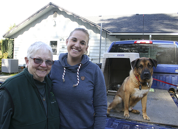
One month later, I wrote to a letter to Hancock Forest Management and included a copy of my article. Would the timber company give us permission to visit Vancouver Notch? Hancock Forest Management Assistant Forester Heather A. Watson responded with an even better offer. She would drive us to the Mowich River and Puyallup River confluence—essentially, the heart of Vancouver Notch.

On Tuesday morning, I met Reid at her home in Puyallup and we drove out to Hancock Forest Management’s headquarters in Orting, where the company manages approximately 100,000 acres of land covered in Douglas and Noble Fir trees. Watson greeted us in the lobby, spread out a color map showing the roads we would take to reach the notch, then led us (and Watson’s Shar Pei / German Shepherd mix, Junior) to her blue, dust-covered Chevy truck parked out back.

Vancouver Notch was approximately 17 miles away, and Watson relayed back to headquarters our location and progress using a handheld GPS / walkie-talkie as we traveled along narrow gravel roads framed by tall stands of sunlit trees and slicing deep into the Mount Rainier wilderness. We passed an old logging camp and kept our eyes open for elk, deer, black bears, and cougars. Occasionally, a heavy-duty truck would approach from the opposite direction, its driver offering a nod or wave of recognition as he passed. Watson drove for nearly 45 minutes. She barely consulted her map, and stopped often to allow us to photograph notch-related features: the rolling and staggered hilltops of The Divide—no longer a distant hump when viewed from downtown Tacoma, but now close enough to decipher individual trees and ridges; and Mount Rainier, which sat large and round on the horizon like a monument.


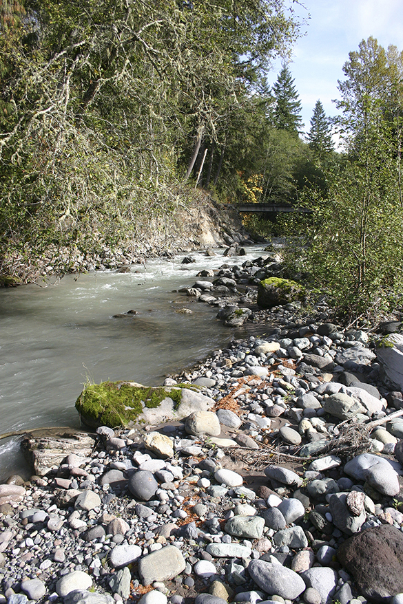
We eventually travelled over two small bridges—one spanning the Puyallup River, another the Mowich River—before we parked and climbed out of the truck. Junior scrambled out of the truck bed and bounded down through thick brush, over mossy rocks, and beneath toppled trees and out toward a rocky spit that reached into the confluence of the Puyallup and Mowich rivers—the heart of Vancouver Notch. Reid and I carefully made our way toward the confluence and stopped to take photographs of the area that had so mystified Captain Vancouver more than 200 years ago. Before too long, we climbed back into Watson’s truck and she drove us back to Hancock’s headquarters. We thanked Watson for the invitation and tour, and headed back to the highway.

On our way to back Puyallup, Reid and I stopped for a late lunch at a cafe in Orting to recap the trip. Our interview has been edited for clarity and abridged for publication.
TACOMA DAILY INDEX: You were finally able to visit Vancouver Notch. What are your impressions of the trip?
BARBARA REID: I thought it was really exciting because we didn’t really know what we were going to get to see. To have that glimpse of Mount Rainier welcoming us, then pinpointing the confluence of the Mowich River and the Puyallup River, then being able to have the clouds lift and have a clear view of The Divide—it’s a whole different perspective to actually be up there at the confluence. I never thought we would be able to see what we saw today.
INDEX: You seemed to be really interested in The Divide during the trip. Heather pulled over at least a couple of times for you to take pictures. Why was that so interesting?
REID: That whole ridge is what creates the ‘V’ and that’s the one that has been geographically named The Divide. That ridge creates that boundary. It is the most prominent part, and is what caught [Captain George] Vancouver’s eye. It’s what creates the abrupt division. He always says the “conspicuous abrupt”—the division in the foothills. It’s appropriately named The Divide because it’s dividing the foothills so the rivers can flow through there. That was what they were always looking at. The fact that he recognized that was a river going through there. We look at it every day and we never even think about that. A river? Really? Which river is it? That was my first question. What river is that? It was a toss up. It either had to be the Puyallup River or the Nisqually River. I was really thinking it was the Nisqually River, originally. That was my first thought because that would be a bigger river.
INDEX: What were your thoughts being down in the confluence? Was it how you had imagined it? Was it bigger? Was it smaller?
REID: It’s bigger. The space between the eastern and the western ridge is actually much wider than I thought it would be so we really didn’t get a handle on the eastern side of where that was and how much bigger the Mowich River was than the Puyallup River. The Puyallup River was smaller, but they were both running really fast. Really fast! Just thinking that for millions and millions of years, those rivers have been coming off those glaciers—the Mowich Glacier and the Puyallup Glacier—and just how important that is on the mountain. All of those rivers feed everything in the whole valley. Just to stand on that land and feel that water rushing by, it’s like a dream come true. I never thought that I would ever get up inside it. I was always hoping that I would fly by it on the north side looking at it as we always see it. But to actually stand at that confluence of those two rivers. I mean, any time you are at a confluence of two rivers or three rivers, it’s a very powerful and energetic point. I always wish at those moments that you can spend more time and sit and meditate and contemplate. It was wonderful.
INDEX: Did you find it odd that it seemed so unreachable, and yet we were there—and we passed how many people in pickup trucks on logging roads [laughing]? It was interesting that it was suddenly very accessible.
REID: It’s a perfect moment. We have been waiting and waiting for months and months. It seemed like it was never going to happen. Just with knowing the right person and contacting the right people, then the doors all swing wide open and we just drive right in.
INDEX: Would it have been better or worse to see it from a helicopter or an airplane?
REID: It’s a whole different view. I never dreamed that I would be seeing the view that we saw because as the foothills mold and fold and wrap around each other, one minute you can’t see anything, and the next minute, everything is right in front of you. It’s just a matter of being at the right place at the right time with the weather. Everything opens up. The fog lifts, the mountain appears, all of the foothills open up just for us. It was our moment and our time. I still would love to be in a chopper and be on the other side, as close as I possibly could, but I’m really content knowing that this was more remote than that would have been. That would have been an aerial view looking down on everything. But we had our feet planted on the ground. I never dreamed that I would be at that point, at the confluence. It’s just remarkable. And then to have the timing as such that we’re now armed with photographs that nobody else has seen that we can take to the Department of Natural Resources. In the beginning, when you first asked me how many people had been in there, I didn’t know. But there is access in there if you get the permits and stuff. It’s just wonderful that we were able to be there.
INDEX: Does this close the book for you? Is there anything else you need to see or know about Vancouver Notch?
REID: I still would like to see the north side looking south in a plane. Preferably a helicopter. Then we are able to say this is what this side looks like, and this is what that side looks like. But we already know what the north view is. Even people who are in there don’t even know what they are looking at. We are really identifying what nobody else has ever seen. Connecting the dots from Vancouver looking at it, connecting the dots to his journal, connecting the dots on the charts and the maps. We just slowly keep adding to the pieces of the puzzle to make it clear for mankind in the future. That’s what is so moving to me. I’m really happy. Historically, it’s very important. It’s a simple thing, but historically it’s important to connect the dots, ask questions of history, and to search for the truth.
More information about Barbara Reid and Vancouver Notch is available online here and here.

UPDATE | FRI., OCT. 23 @ 5:30 P.M. — The Washington State Committee on Geographic Names approved Reid’s proposal during a public meeting this morning. A link to the press release is online here.
To read the Tacoma Daily Index‘s complete and comprehensive coverage of Vancouver Notch, click on the following links:
- Tacoma Daily Index Top Stories — October 2015 (Tacoma Daily Index, Nov. 2, 2015)
- Vancouver Notch: Committee approves proposal to name Mount Rainier foothills feature (Tacoma Daily Index, Oct. 26, 2015)
- Vancouver Notch: In Mount Rainier’s foothills, Barbara Reid completes one famous explorer’s journey (Tacoma Daily Index, Oct. 21, 2015)
- Vancouver Notch: Committee to consider proposal to name Mount Rainier foothills feature (Tacoma Daily Index, Oct. 19, 2015)
- Tacoma Daily Index Top Stories — August 2015 (Tacoma Daily Index, Sept. 1, 2015)
- Vancouver Notch: Mount Rainier foothills could soon honor the late explorer (Tacoma Daily Index, July 31, 2015)
Todd Matthews is editor of the Tacoma Daily Index, an award-winning journalist, and the author of several books. His journalism is collected online at wahmee.com.
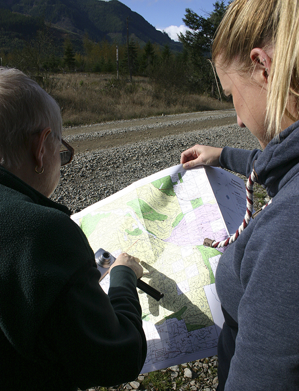
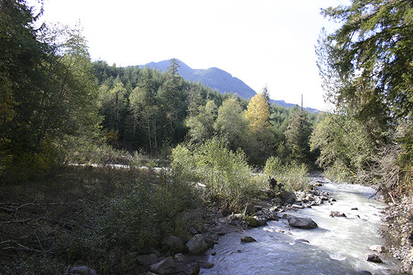
Barbara Reid and Hancock Forest Management Assistant Forester Heather A. Watson consult a map. A section of The Divide is in the distance. (PHOTO BY TODD MATTHEWS)
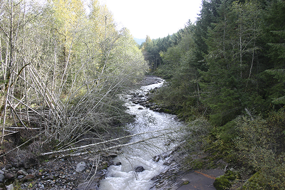
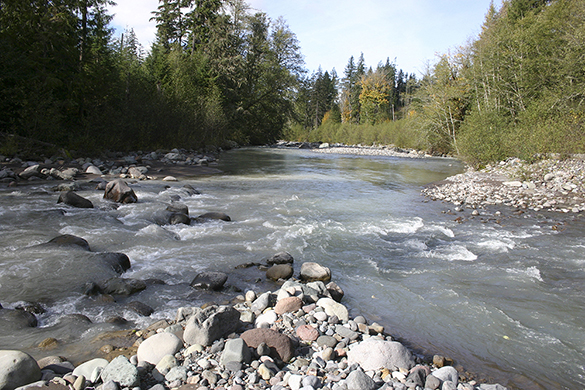
The Puyallup River (left) and the Mowich River (right) confluence in the heart of Vancouver Notch. (PHOTO BY TODD MATTHEWS)
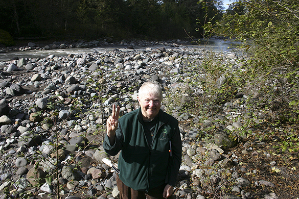
Barbara Reid in the heart of Vancouver Notch, the confluence of the Mowich River (on her left) and the Puyallup River (on her right). (PHOTO BY TODD MATTHEWS)