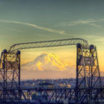
The Washington State Board of Natural Resources is scheduled to vote in December on a Pierce County resident’s proposal to officially designate a v-shaped mountain pass in the foothills of Mount Rainier in honor of the late British Navy Captain George Vancouver.
In the spring of 1792, Vancouver was aboard the H.M.S. Discovery in Puget Sound and surveying the natural environment when he noticed the geological feature. Vancouver, whose ship was anchored at Restoration Point on the southern end of Bainbridge Island, noted the feature in his journal—“The appearance of a very abrupt division in the snowy range of mountains immediately to the south of Mount Rainier, which was very conspicuous from the ship, and the main arm of the inlet appearing to stretch in that direction from the point we were then upon”—and boarded one of two smaller boats that headed south, past Vashon Island, and into Commencement Bay, only to find what he believed to be a dead end. Vancouver noted: “We were excessively anxious to ascertain the truth, of which we were not long held in suspense. We found the inlet to terminate here in an extensive circular compact bay, whose waters washed the base of mount Rainier.”
Vancouver would go on to name dozens of mountains, waterways, and islands in the Puget Sound area—but the v-shaped notch remained nameless and largely elusive. Many historians believe Vancouver wondered if the large, concave feature could have signaled an opening to The Northwest Passage.
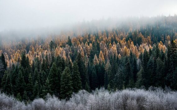
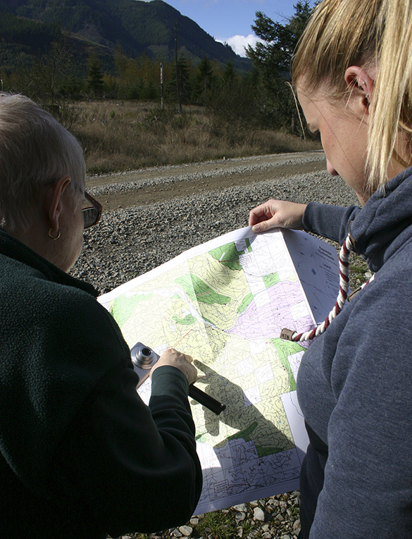
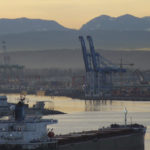
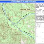
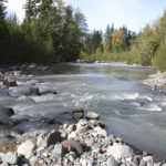
A proposal to formally name Vancouver Notch was submitted earlier this year by Puyallup resident, retired Army veteran, and maritime historian Barbara Reid. On maps, Reid was able to pinpoint the heart of the notch to land owned by Hancock Forest Management and located approximately 12 miles west of Mount Rainier, where the Puyallup River and Mowich River intersect. It is bounded on one side by an 1,800-foot ridge known as “The Divide.”
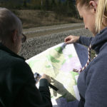
In July, the Tacoma Daily Index was first to publish a feature article about Reid and her proposal (see “Vancouver Notch: Mount Rainier foothills could soon honor the late explorer,” Tacoma Daily Index, July 31, 2015) and it proved to be a popular article among our readers (see “Tacoma Daily Index Top Stories — August 2015,” Tacoma Daily Index, Sept. 1, 2015). In August, the Tacoma Daily Index wrote to Hancock Forest Management requesting to visit the proposed Vancouver notch area. In October, the timber company invited Reid and the Tacoma Daily Index onto the property to visit and photograph The Divide, the notch, and the Puyallup River and Mowich River confluence (see “Vancouver Notch: In Mount Rainier’s foothills, Barbara Reid completes one famous explorer’s journey,” Tacoma Daily Index, Oct. 21, 2015; and “Tacoma Daily Index Top Stories — October 2015,” Tacoma Daily Index, Nov. 2, 2015).
The Washington State Committee on Geographic Names approved Reid’s proposal during a public meeting in October at the Washington State Department of Natural Resources headquarters in Olympia (see “Vancouver Notch: Committee to consider proposal to name Mount Rainier foothills feature,” Tacoma Daily Index, Oct. 19, 2015), Reid and the naming committee’s executive secretary, Caleb Maki, briefed the committee on the proposal and shared a slide show of maps and photographs of the area.
“The proponent [Barbara Reid] wanted to commemorate Mr. Vancouver because in 2017 it will be 225 years since he explored the southern waters here in Puget Sound,” Maki told the committee. Maki noted he received letters of support from Pierce County officials and members of the public. “We got a lot of public comments. Really, nothing negative. All in all, it was a good proposal. The proponent was actually lucky enough that the landowner—who we didn’t hear back from, but being how they let her on the property, I would assume they would have no problem with it—they actually let her go up there and check out the feature.”
Maki also noted there is only one other officially named notch in Washington State—Grizzly Notch in King County.
Reid shared photographs of her trip to the The Divide, as well as the Mowich River and Puyallup River confluence. “It was interesting to me how little the Puyallup River was that far up in the notch, and the Mowich [River] was actually greater,” Reid told the committee. “The distance from The Divide to the confluence of the Mowich and the Puyallup is about two miles. That gap, that notch area, is just enormous, which was surprising to me.”
According to information posted on the Washington State Department of Natural Resources Web site, the proposal is now scheduled to go before the Board of Natural Resources (acting as the Washington State Board on Geographic Names) for a final decision during a public meeting that begins at 9 a.m. on Tues., Dec. 1, at the Natural Resources Building (Room 172), located at 1111 Washington St. SE, in Olympia. A copy of the agenda is available online here and here.
Names approved by the Board are published in the Washington Administrative Code and forwarded to the United States Board on Geographic Names for federal consideration along with the state’s recommendations. In the end, the name Vancouver Notch would be entered into a database maintained by the U.S. Geological Survey and used by most cartographers to create maps. “You really want to get in the database,” Maki told the Tacoma Daily Index earlier this year. “Responsible cartographers pull the names from that database.”
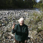
!["It's really worth the effort to get this named to honor [Captain George Vancouver]," said Puyallup resident Barbara Reid. She has submitted an application to name a feature of the Mount Rainier foothills Vancouver Notch in honor of the late explorer. "I think it's important. It's part of the landscape that we see everyday.I think it's really important to shed light on." (PHOTO BY TODD MATTHEWS)](https://www.tacomadailyindex.com/wp-content/uploads/2015/07/080315_vancouver_notch_f_web-150x150.jpg)
To read the Tacoma Daily Index‘s complete and comprehensive coverage of the proposed Vancouver Notch, click on the following links:
- Tacoma Daily Index Top Stories — October 2015 (Tacoma Daily Index, Nov. 2, 2015)
- Vancouver Notch: Committee approves proposal to name Mount Rainier foothills feature (Tacoma Daily Index, Oct. 26, 2015)
- Vancouver Notch: In Mount Rainier’s foothills, Barbara Reid completes one famous explorer’s journey (Tacoma Daily Index, Oct. 21, 2015)
- Vancouver Notch: Committee to consider proposal to name Mount Rainier foothills feature (Tacoma Daily Index, Oct. 19, 2015)
- Tacoma Daily Index Top Stories — August 2015 (Tacoma Daily Index, Sept. 1, 2015)
- Vancouver Notch: Mount Rainier foothills could soon honor the late explorer (Tacoma Daily Index, July 31, 2015)
Todd Matthews is editor of the Tacoma Daily Index, an award-winning journalist, and the author of several books. His journalism is collected online at wahmee.com.